
I have assembled an open source map dataset of the entire Appalachian Trail (AT) which can easily be loaded onto your Android phone and used offline. I felt this might be a little electronic trail magic for hikers planning their next trip. The dataset includes maps of a few miles on each "right" and "left" side of the AT trail, GPX track files of the trail itself, shelter locations, and shelter information. My favorite offline GPS app for Android, and the one I have field tested the most is OruxMaps, so these maps are formatted specifically for that app and will not work with any other GPS system. I am currently looking into making an iPhone version.
These trail maps were created by and for an AT backpacker. We are usually on a tight budget, we like to travel with as little gear/weight as possible, we want our batteries to last as long as possible, and for safety reasons we need topographic maps with contour lines, elevation markings, and roads. The maps and tracks which I have assembled are FREE, as is the OruxMaps app. AFAIK this is the only free and open sourced maps of the AT. You can use them offline, so you won't need any network connectivity, thus you can keep your phone in airplane mode all day, a huge battery saver! This brings more to the phone which you were already going to carry, instead of buying paper maps or other GPS hardware, saving you both money and pack weight. Paper maps are obviously more reliable, and dedicated GPS units more functional, so this method is not for everybody. Test the software thoroughly before embarking on your trip, do battery life tests, and think about redundancy like carrying data backups, a heavy duty case, screen guard, extra batteries, guidebook, paper maps, etc.
The trail maps and tracks are split up into 39 numbered segments, moving sequentially from Georgia to Maine. OruxMaps will perform faster and more efficiently when they are split up like this (preserving your batteries). I also included a single track file of the whole trail including shelters, for when you want to browse the trail at a more broad scale. Here is how to get these AT maps running on your Android.
Android Setup Instructions
Download to your computer this file: AT-OruxMaps-rev-1.0.zip (338 MB)
Unzip the downloaded file. It contains two main directories, mapfiles and tracklogs
Install the latest version of OruxMaps onto your Android phone
Plug your phone's USB cable into your computer, choose the mount as disk drive option
Locate the mounted disk drive and the /oruxmaps/mapfiles folder within
Copy the the 39 folders in mapfiles named Atlas01, Atlas02, Atlas03, etc to /oruxmaps/mapfiles
Don't copy the mapfiles folder itself, just the folders inside the mapfiles folder
Locate the mounted disk drive and the /oruxmaps/tracklogs folder within
Copy all 42 gpx files in tracklogs named Track01.gpx, Track02.gpx, etc to /oruxmaps/tracklogs
Don't copy the tracklogs folder itself, just the files inside the tracklogs folder
Unplug the USB cable making sure you properly eject the mounted disk drive
OruxMaps Usage
Start the OruxMaps app, it should recognize and process the maps and tracks you copied, may take a minute.
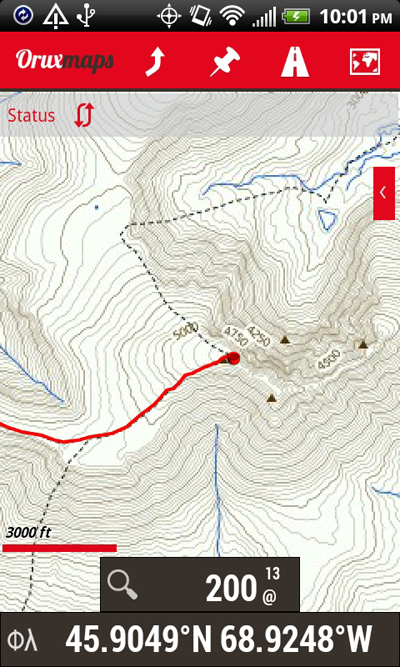
Click the map icon in the upper right corner of OruxMaps, choose Switch map, then Offline, then Atlas01.
You should see a map of NE Georgia. Springer Mountain! But where is the trail and shelters?
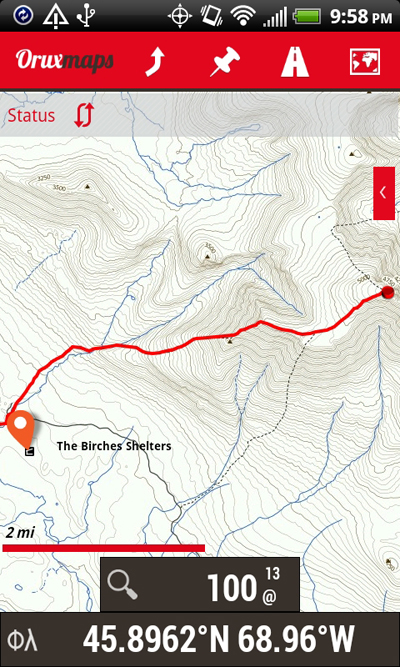
Its easier to load the shelters first, so click the street icon in the upper toolbar, and choose Load file, then Shelters.gpx.
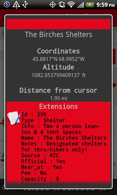
You should now see a bunch of shelter pins, two-finger zoom in and click a pin to see data relating to that shelter.
Click the street icon in the upper toolbar again, and choose Load file again, now Track01.gpx.
You should now see the Appalachian Trail in addition to the shelters.
Important! To properly zoom the maps, you need to go to Settings, then Maps, then Zoom settings, then Pinch to zoom set it to Combined zoom.
That zoom option allows you do zoom level 13 at 200%, 300%, or even 400% so you can see contour lines and elevation markings.
To get the maps to auto-load as you move around, go to Settings, then Maps, then Auto load maps set it to Scrolling out of avail range.
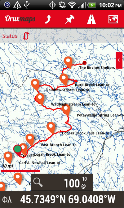
That option is useful when browsing the entire trail, and you can also load AllTracks.gpx file when doing that.
That option might be distracting when you are focused on a particular trail area.
And the full AllTracks.gpx file is large and will slow down OruxMaps.
You can unload open track files from the map by clicking the street icon and then Remove, then you can load a new track.
If you want to quickly jump to a map (Atlas01, Atlas02, etc) or track (Track01, Track02, etc) then click the map icon then Move to then choose.
Play around with the app and the many settings available...
Battery Tips on the Trail
Buy a larger battery for your trip! Try 3500mAh size, and a good reliable brand like Seidio. Bring your old battery as a backup.
During the day while you are hiking keep the phone in Airplane Mode but with GPS turned on.
Power your phone off unless you are actually viewing OruxMaps and/or checking your coordinates.
At the end of your hiking day turn the GPS off.
Don't use the large AllTracks.gpx when you are out on the trail. Use an AtlasXX map with the same number TrackXX track.
Turn your screen brightness down (unless you are out in the open sun).
Uninstall apps that you definitely won't need! They might be wasting CPU cycles in the background, even during Airplane Mode.
I have gotten 5-6 days on the trail in one battery charge, using OruxMaps throughout the day.
And of course also using phone as an mp3 player, reading books, flashlight, txt messaging, etc. What a world we live in.
Copyright and License
These maps are open source data! Thanks to OpenStreetMap contributors and the TopOSM project, copyright and license information is here. Map rendering provided generously by Stamen Design. The Appalachian Trail tracks and shelter waypoints are courtesy of Guy Mott and were taken from his page where you can learn more about the accuracy of the track data. The tracks of his which I am including in the zip download below are called Appalachian Trail GPS Tracks, Filtered 50 Feet and AT Shelters - Long Comments.gpx. Using OruxMaps I have tested his track data on about 300 miles of trail in Virginia, and found it to be very accurate. You can certainly experiment with his other track files, or even ask Google to find you different ones.
Disclaimer
You are using these maps and data at your own risk. I cannot be held liable for the accuracy of these maps and data. I cannot be held liable for any harm which may occur to your electronic equipment from these maps and data. I cannot be held liable for your safety in the backcountry. Be smart. Be safe. Have fun!
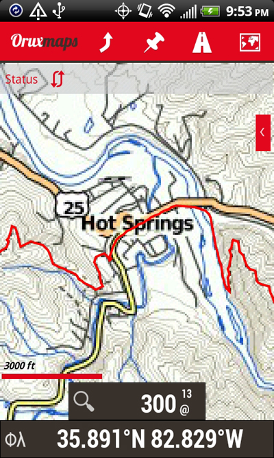
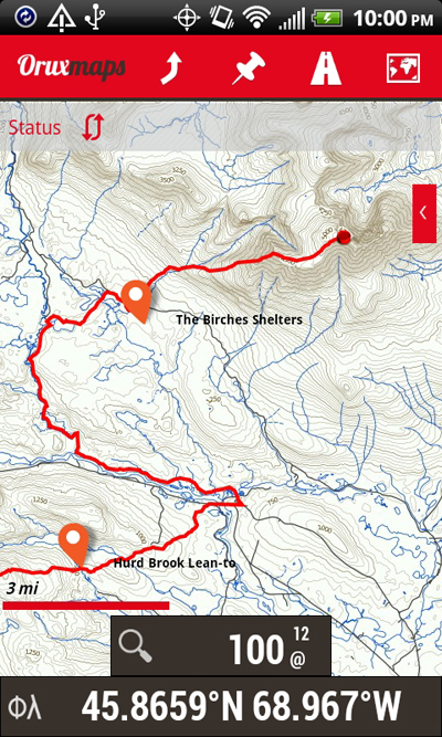
Some Screen Captures